Local history is part of the Key Stage 2 History curriculum. It was therefore quite clear that the history of Plotlands - being literally on the doorstep - was there for the taking. Lincewood Primary School was about to introduce its Year 4 pupils to mapwork, local history, archaeology, social history, family history, the skills of observation, recording and classification, numeracy, and literacy - all bound up in one exciting project where the pupils took on 'ownership' of their finds - and rightly so too. They were about to build on a one-day introduction that they'd done down at 'The Haven' in Year 3, by first of all finding their way around the northern part of Langdon Hills: Lince Wood. This is old.
Barry Howard undertook a series of 'starter'lessons by simply doing a number of 'walking-talks' around Lince Wood - a lot of 'ups' and 'downs'. The pupils were relating the map to what they saw on the ground - and what they saw on the ground back to the map - a true navigation skill. Every footpath was walked at least once.
Maps were located, on the internet, of the plotland sites. However, the pupils found more than the maps could ever tell them - after all they were 'there' both within the school grounds and amazingly just outside, with, as they found out (and are continuing to find out) virtually complete gardens and foundations - and sometimes actual walls - of the former properties. These are being currently mapped. Barry Howard is mapping the whole of Lince Wood at 1:10,000 scale - at a detail of plotting every tree along every footpath; this alone is a two year project for his company 'Hunter Outdoor Training', but a very worthwhile one as there is no large scale map of the area.
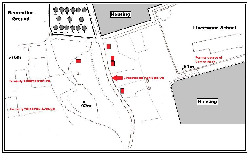
ABOVE: not the detailed survey that Barry Howard is undertaking but the working field map that was the very first map-tool we used to orientate the pupils. The red rectangles are the sites outside the school that the pupils recognised as having evidence of former habitation.
The two 'roads' that Lincewood pupils are mainly (but not exclusively) interested in are Lincewood Park Drive - which is right outside the western boundary of the school fence, and Corona Road which ran right through what is now the school site.
We have managed to find that the names of the houses in Lincewood Park Drive were:
The Limes Lincewood Cottage Lincewood Bungalow Joylands** The Nook Jessie Cottage Eastney Underwood June St. Olafs The Trees Lincewood Woodside Margaret Dilkusha Napier Lodge Somerleyton Rowarl Eston The Laurels Kilcan Poplars The Maples Homeland Ernden.
The names of the houses in Corona Road were:
Bank Riggs High View Davidstan Lil Fantana St. Ronans Bonnydene Francis Aldoral Baradine Malva Corona Fairview Montreal Avalon Toulon
** We believe that Mr. William Flemons lived here in Joylands very close to the school site. The pupils are on a mission to find out about Mr. Flemons and if he has any descendants still living in the Langdon Hills area.
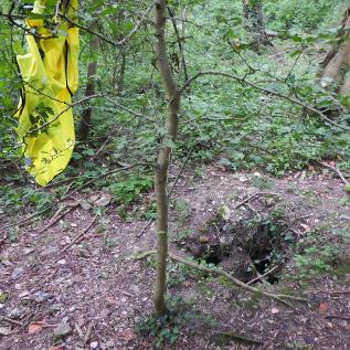
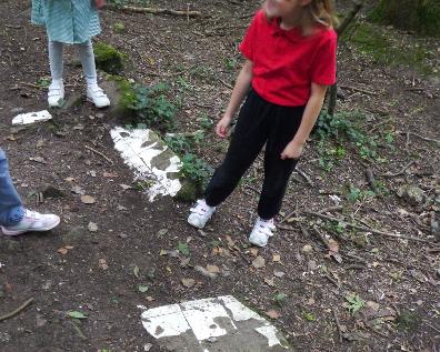
ABOVE LEFT: Evidence.....the former cess pit (we think), about three metres deep, and hence the hi-vis jacket hanging up to warn all! ABOVE RIGHT: Evidence: large slabs of ceramic wall tiles alongside the Lincewood Park Drive track.
HISTORY:
Langdon appears in Domesday Book as Langduna. 'Lang' meaning long, and 'dun' - in Anglo Saxon eastern England as meaning hill. Laindon and Langdon still get confused - but it is thought that Laindon has its meaning linked to a Celt word: 'Lyge' which was the name of the stream flowing from the present site of Laindon Church into the River Crouch. Man has lived in this area for a long time. There is evidence that at the top of the northern Lince Wood section of Langdon Hills there was an Iron Age hill fort which along with the important (though lower)hillfort at Asheldham near Maldon has shown to be rich in 5th century BC pottery.
However, we are concerned with the history of the plotlands:
In 1951 a survey was done by people from the government who wanted to see how much of the local land was covered in 'plotland' properties. They found that there was:
75 miles of grass track roads, 8,716 plotland dwellings - and 6,000 of these had no sewerage system - 2,045 properties were built of brick and tile (so quite good then), 6,000 were of 'light' and/or poor shack type buildings. Only 1800 were classed as 'chalets in good condition'.
These then were all destroyed. We are now finding more and more evidence of where these properties were.
ABOVE: A former garden of a plotland site - quite a 'give-away' in the middle of the woodland.
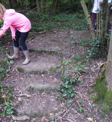
ABOVE: "Mr.Howard!!!!! We've found some steps!!!!
What pupils have to understand is that the things they have found were peoples' property: the very cups, plates, dishes and bowls that we've found were used as part of peoples' everyday life. They left these things behind when they had to move away because although used everyday, they were not valuable. The valuable things they took with them! We do not find personal things; they were very special to those that lived here in: Corona Road, Lincewood Park Drive, Alexander Road, Woodlands Avenue, Recreation Avenue, Egerton Drive, Wheaton Avenue, and Molly's Drive.
What we have been left with is more than enough to help us imagine some of the ways of life of the plotlanders. These are the things that they could leave in the house when the family went back to London to their main home.
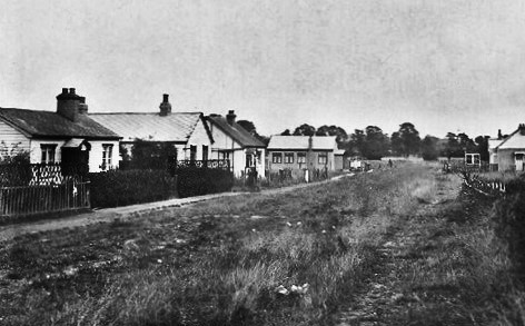
ABOVE: Elizabeth Drive in the Lee Chapel (east) part of Laindon, looking east during very early Autumn 1950. The railway is close by just out of sight on the right (south) of the road.